Geo-spatial visualization for music prints
Wednesday, July 1, 2015
In many domains, data visualization techniques have proven to be extremely useful for analyzing and better understanding large and complex datasets. We recently conducted experiments on how geo-visualization techniques may be applied to music bibliographical resources.
With the online publication of the RISM datasets, a large range of new opportunities has now opened up for the musicological world. However, working on and analyzing datasets of thousands of records raises new challenges for musicological research.
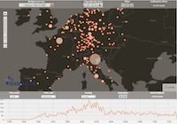
We present here an innovative way of visualizing music prints data from RISM Series A/I for prints from before 1730. This approach not only provides scholars with completely new ways of apprehending the data, but also offers new possibilities of selecting and manipulating the data for further processing and analysis.
Share Tweet Email